Gerrymandered, U.S.A.
Gerrymandered, U.S.A.
In the last Fun With Maps, we talked about a Pennsylvania congressman drawn out of his own district by mere yards. Though that’s a particularly targeted example of gerrymandering, it’s certainly not the most egregious. Let’s look at some of the most rigged.
The Horseshoe: IL-04
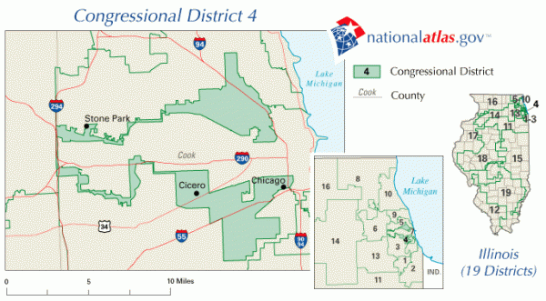
To create a Hispanic-majority district in the Chicagoland suburbs, the state of Illinois combined a Puerto Rican neighborhood with a distant Mexican neighborhood via a nonresidential strip of Interstate 294. The problem? The highway is eight miles west of either enclave.
The Court Case: NC-12
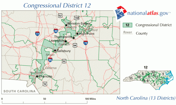
Pro tip: If you’re looking at a long, narrow district, you’re probably looking at some gerrymandering. When North Carolina gained a seat in the House of Representatives following the 1990 census, the state set out to create a black-majority district in NC-12. The twelfth initially followed Interstate 65 from Gastonia to Durham. Durham is 160 miles south north of Gastonia, at its widest the district was less than 20 miles across. The current version is the result of a 1993 Supreme Court ruling that the shape of the district violated the Equal Protection Clause. What you’re looking at now is actually considered acceptable.
The Snake: MD-03
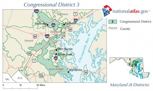
How do you create a Democratic-leaning district out of a smattering of Republican neighborhoods? You carve yourself Maryland’s 3rd. Drawn to its current extent after the 2000 reapportionment, MD-03 appears barely cohesive. [We formerly credited the elections of Barbara Mikulski and Ben Cardin to this redrawing; Mikulski was first elected to the House in ’77 and to the Senate in ‘87.]
The Claw: CA-11
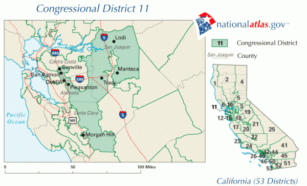
Gerrymandering doesn’t always work out, especially if the candidate is particularly terrible. Take California’s 11th. When it was reapportioned in the early 2000s, GOP incumbent Richard Pombo was barely hanging on to his swing state seat. Even though it was drawn very precisely to excise the Lawrence Livermore National Laboratory and surrounding scientist-filled neighborhoods, Democrat Jerry McNerney emerged victorious in a 2006 less-close-than-you’d-think race despite never having held elected office. Flash fact, when ranking all 435 districts by area, CA-11 is the median in size. Flash fact II, Pombo is now running for office in CA-19. He is not a resident of CA-19.
The Pie: Columbus, Ohio
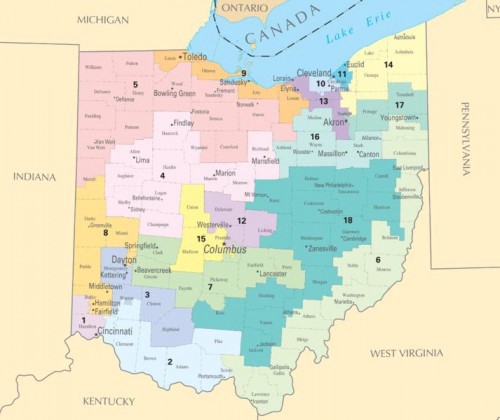
A gerrymander isn’t always used to favor a specific candidate or voting bloc. Sometimes you just want to disenfranchise some folks. Spreading a voter group through several districts, also known as ‘cracking,’ can deny fair representation to a large constituency. The liberal center of Columbus, Ohio, is divided into three individual districts, each including a small slice of the urban area and a wide swath of the generally more conservative suburbs.
The Nonpolitical Gerrymander: AZ-02
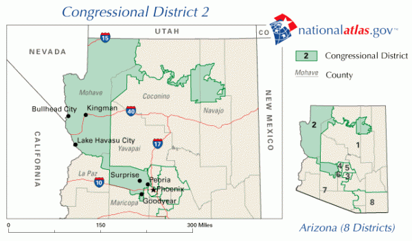
Similar to the Hopi/Navajo time zone pickle mentioned last time, the Hopi and the Navajo have had such major conflicts that Arizona lawmakers thought it best to separate their tribal lands into different districts. The blob of Hopi land to the northeast, which is completely surrounded by Navajo land, is connected to the rest of AZ-02 via a narrow strip of labyrinthine riverbeds. Navajo voters cast their ballots for candidates running in AZ-01.
The Meatwad: CA-18
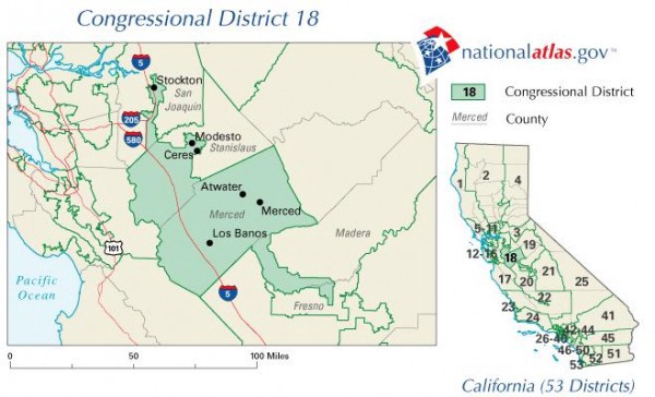
Not particularly gerrymandered, but it looks like meatwad.
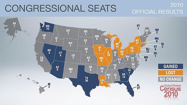
Districts are reapportioned in the years following the decennial census. This time around, Texas is gaining four seats and Florida is gaining two. Arizona, Georgia, Nevada, South Carolina, Utah and Washington will each gain one. Illinois, Iowa, Louisiana, Massachusetts, Michigan, Missouri, New Jersey and Pennsylvania are losing one seat. New York and Ohio are each losing two seats. North Carolina, with no change in seat allocation, is shaping up to be a doozy. Definitely a state to watch as the lines are redrawn. If watching isn’t enough, may I recommend the Redistricting Game?
Victoria Johnson’s hometown district, NY-27, looks like a bow tie.
Maps of Ohio and post-census reapportionment from the Census Bureau; all others from nationalatlas.gov.