Fun With Maps: Seven Peculiar U.S. Borders
Fun With Maps: Seven Peculiar U.S. Borders
Is Colorado a perfect rectangle? The borders are defined by strict latitude and longitude lines, so by all accounts it should be; but thanks to a surveyor error back in 1879, it isn’t. The kink in the western side of America’s Otherwise Squariest Landmass is just one example of the kind of cartographic aberrations that have made for oddball borders in today’s United States.
Kalawao, HI
Hawaii is composed of five counties: four counties of comparable size and one 13-square-mile blip, Kalawao County. This small size is because Kalawao County (on the island of Molokaʻi) governs the Kalaupapa Leprosy Settlement and National Historical Park and nothing else. The two even share the same borders. Founded in 1865 by King Kamehameha V and his legislative assembly, Kalaupapa was a forced settlement camp for sufferers of Hansen’s Disease, a.k.a. leprosy. The site was chosen for its incredibly fertile volcanic ash-based soil — it was believed this soil would make it possible for residents to sustain themselves by farming. Which was just as well as the other reason the site was chosen is because it’s completely cut off from the rest of the island by a 2,000-foot cliff.
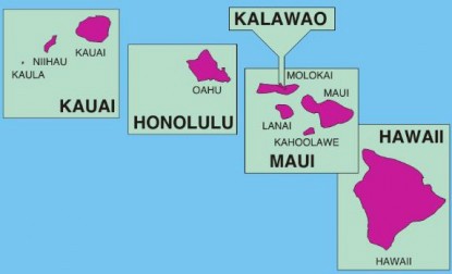
Kalawao County was created in 1905. Most of its administrative tasks are handled by Maui County, and Kalawao’s sole local official is a sheriff chosen from among the resident population by the state health department. Though the quarantine ended when leprosy was cured in the ’60s, people must still have state permission to visit and no one under the age of 16 is allowed unless they’re a relative of one of the hundred(-ish) elderly leprosy survivors that reside in the county. When the leprosy survivors all die off, it’s expected that Kalawao will be formally annexed by Maui County. (Picture via wikipedia)
Kentucky Bend
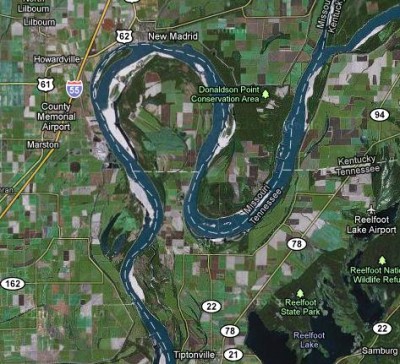
The Kentucky Bend is an area of Kentucky that sits completely within Missouri and Tennessee, disconnected from the rest of its own state. To understand how this came to be, we have to look at the entire southern border of Kentucky. Kentucky was once part of Virginia and, in the process of becoming a territory, kept the same southern borders (at 36°30’ N, halfway between the entrance of the Chesapeake Bay and the Albemarle Sound in North Carolina). A few years later, Tennessee separated from North Carolina and, like siblings arguing over the middle seat in a family car trip, each territory accused the other of taking its land.
Thomas Walker, surveyor, set the uneven border between the western edge of Virginia to the Tennessee River as it exists today. The area past the Tennessee River, purchased from the Chicksaw tribe at a later date, stretches to the Mississippi border and sets the border back at the original line, 36°30’ N. West of the Mississippi, it’s Missouri. However, there is a tiny thumb of land both east of the Mississippi and north of 36°30’ — the Kentucky Bend. The fifteen Kentuckians who live there send their children to schools in nearby Tiptonville, Tennessee.
Ellis Island
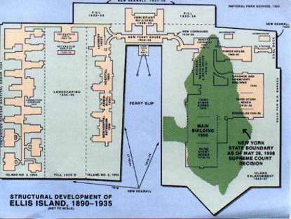
Ellis Island is partially in New York and partially in New Jersey. Both Ellis and Liberty Islands in New York Bay are technically on the Jersey side of the border, but as they were under NY control before the river was divided, they remained part of NY. But that only applies to what is above ground; the water is in Jersey’s jurisdiction.
When Ellis Island was artificially enlarged in the early 1900s through land reclamation (that is, blocking off an area of water, draining it and filling it with earth; the same process used to create the land used for Wellington, New Zealand’s harborfront and about a fifth of The Netherlands), New Jersey had a legitimate claim: the reclamation project enlarged Ellis Island by 90% and New Jersey argued that the land reclaimed from the bay was theirs. New York got away with the enlarged island until 1998, when New Jersey’s lawsuit against the state of New York reached the Supreme Court. In a 6–3 decision, the Court ruled that while the naturally occurring island belongs to New York, all of the manmade land belongs to New Jersey. Essentially, New York earns tax revenue from souvenirs sold in the museum and New Jersey collects payments from the utilities it provides to the New York section.
PA-20
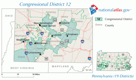
Elected to the House in 1994, Army veteran Frank Mascara served as representative of Pennsylvania’s 20th district, located in the southwesternmost corner of the state. Following the 2000 Census, GOP-led redistricting eliminated the 20th and redrew Mascara into fellow Democrat John Murtha’s district, PA-12. The borders were so cleverly gerrymandered that Mascara’s house in Monessen ended up in Murtha’s district 12, but his parking spot was in district 18. Had his house been drawn in 18, Mascara would have been up against a relatively weak incumbent Republican. Instead, forced to campaign against a popular Democrat incumbent, Mascara lost by a wide margin.
Arizona
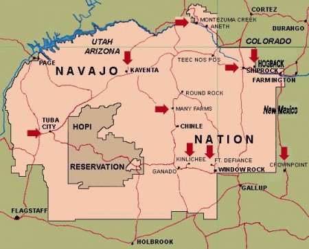
The state of Arizona does not observe Daylight Savings Time. The Navajo Nation in Arizona does observe Daylight Savings Time. The Hopi Nation, an enclave within Navajo land, does not observe Daylight Savings Time.
Rio Rico, Mexico
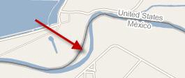
The Texas-Mexico border has been set as the Rio Grande since 1845. So when an irrigation company illegally altered the river’s course in 1906, a tiny section of Texas was separated from the rest of the state. Though technically US territory, Mexico absorbed the area as a sort of resort town, a US territory without enforcement. The area was officially annexed by Mexico as the Horcon Tract under the Boundary Treaty of 1970, a provision of which granted US citizenship to anyone born on the 400 acres after 1906.
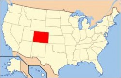
Colorado
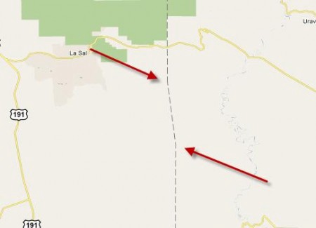
Colorado certainly looks like a rectangle. The official borders all correspond to latitude and longitude. On the northern side, the border is shorter than the southern one because circles of latitude get shorter as they get farther from the equator and closer to the poles. The state is seven degrees of latitude from east to west and four degrees of longitude from north to south, so the northern border is about 34 km shorter. But there’s a kink in the western border with Utah. Once Colorado was granted statehood, a team of surveyors traveled northwards from 37°N to 41°N, leaving mile markers as they went, as was customary. Deep in rough terrain they slipped a tiny bit west. Though Congress specified 109°03’W as the edge, the official borders are not what is legislated on paper but what is actually marked on the ground. So an error remains along the western border of Colorado, a confirmed non-rectangle.
Victoria Johnson is a cartographer and this is her Tumblr.
Image sources, from top: Maps of United States and Kalawao via Wikipedia; Kentucky Bend image from Google Maps; Ellis Island via NPS.gov; PA-20 via the National Atlas; Rio Rico and lower Colorado map detail both from Google Maps.